Parcel lot dimensions have been on our road map for quite a while. It’s not a simple feature to build when all the nuances are considered, but I’m extremely happy with the results. We soft-launched the feature last week so some of you have already started playing with it. If you’re a premium Scoutred user you will now see the length of each parcel line segment as shown in the following screen shot:
Over the last several years Scoutred has been exclusive to San Diego County. San Diego is our home so it made sense for us to focus where we could connect with our users and understand their needs. I have consumed a fair amount of coffee meeting many of you, learning about your operations and understanding the pain points you deal with on a daily basis. Though Scoutred has evolved to address many of your requests, an important missing feature has been lingering until now: Scoutred in more markets.
After an extensive journey deep into the world of GIS, raster map rendering and PDF generation, I’m excited to announce v1.0 of Scoutred’s beautiful PDF property reports!
In order to produce the property profiles Scoutred users are use to, it’s necessary to manage a rather large GIS dataset. Often times it’s necessary to navigate through numerous pages for zoning maps, community plan details or review permits for a property. This is all straight forward on Scoutred, but up until now there has not been an easy way to package up the Scoutred experience into a nice clean report that can be take with you.
As the ScoutRED user base has grown so have the requests for more data. Towards the end of 2016 it was apparent that permit data would be a valuable addition for many users, so we set out to make that happen. After several months of work we’re excited to finally release the beta version of our Permit Search. It’s fast, beautiful and full of over 300,000 permits from the City of San Diego from 2003 to present. For the first time all the permit data in Open DSD has been unlocked so it’s actually searchable. The permit scope, contractor, project, permit id, etc. are all available for lightening-quick searching. Oh, and the data updates every week so it’s always fresh.
Working with large geospatial datasets can be cumbersome and time consuming, especially when you only need a subset of the data for a presentation or to start a new project. Loading gigabytes of data into GIS programs, familiarizing yourself with the dataset then zooming and clipping the outlines can take hours of your work day. Alternatively you can pull a parcel map and then trace the target parcel and the surrounding area, or you can use ScoutRED’s new parcel lot line download feature.
Since the beginning, Scoutred has been a side project for me. In the software world side projects are a way to explore an interest and identify if there is a need. In this case my interest stemmed from combining my backgrounds in real estate development and software development. I recalled the issues I had around data research while doing land development in Colorado, Nevada and Arizona and I knew something like Scoutred would have been an immense time saver.
This release has been a major technical overhaul. Initially we started an effort to support various overlay zones that can modify the available uses of real estate. As we worked through the various datasets, it was clear that our database schema was not going to scale, while maintaining the performance users of ScoutRED have come to expect. It has been a large effort, but we’re quite happy with the results.
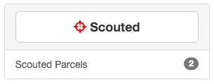
Millions of parcels and no way to save them, until now. Today we’re excited to release a way to collect parcels for easy future lookup. We call it “Scouting” and it all starts with the new Scout button on every parcel page:
To Scout a parcel, simply click the Scout button on any parcel page. The button text will change from “Scout” to “Scouted” and the parcel will be saved to your default “Scouted Parcels” collection. To remove the parcel, simply click the button again.
A GPS integration has been on our roadmap for quite awhile now and we’re excited it’s finally ready. If you’re in the field and need access to ScoutRED property data, simply open up ScoutRED on your mobile device and tap on the GPS icon located to the left of the search field. We will detect your location and move the map accordingly. Life in the field just got a whole lot nicer. ;-)
The bounding box of the map viewport is used to fetch the neighbors.
A maximum of 100 neighboring properties will be populated. This matters most when a property is large and the viewport is zoomed out. Loading in thousands of neighboring properties was resuluting in large amounts of data transfer and slowing down the map experience.
Hovering over neighboring properties will highlight them
Clicking on neighboring properties will take you to that property’s details